This exhibit provides a glimpse into the changing landscape of food provision both here in North Adams and in the nation as a whole. Many years ago, we walked to different stores for meat, baked goods, and vegetables, typically buying one or two days' worth of food at a time. Over the years this type of shopping excursion evolved to the supermarket of today, where all the shopping can be done within a single location, and food may be purchased for a week or more at a time.
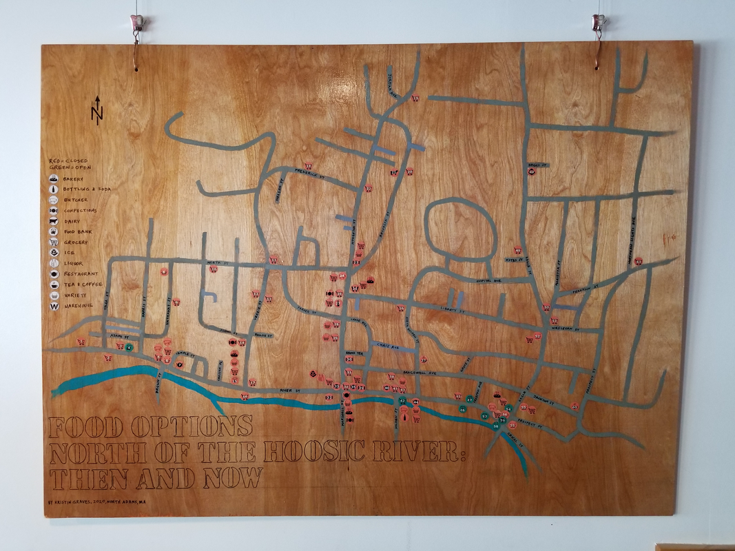
A total of 61 unique locations have been identified north of the Hoosic River, as shown on the large map above. The numbered dots identify the 61 locations, with further information about each provided in this notebook. In addition to the numbered dots, additional dots at each location indicate the types of businesses that previously existed at that location. Today, only 8 of the 61 locations are operational (identified with green dots on the map), and half of them are food pantries.
This exhibit includes several parts:
- The large wall map.
- Six smaller wall panels, each of which focuses on a different aspect of Kristin's research for this project (shown in a slide show below).
- A notebook, which consists of four sections:
- Background Info -- This section includes pictures, maps, and other information related to each of the 61 locations. This section is organized by street, so that you can take a virtual "walk" down the street to see the various locations. A 10-minute movie of the background information is available below.
- Address List -- This is a list of each of the 61 locations, organized by street. The list includes the map ID number, store address, the name of the store, what type of business it was, and the approximate decades that it was in operation. See "List of Stores by Street" below.
- Map Number List -- This is a list of the 61 locations sorted by the map number. This list includes the same details as the Address List. See "List of Stores by Map ID Number" below.
- Name List -- This is a list of the 61 locations sorted by the name or the store and/or owner. Use this list to look up your family, friends, or stores you remember. This list includes the same details as the Address List. See "List of Stores by Name" below.
- After dark, the Background Info from this notebook is projected onto the window of the River Street Art Project and Christopher's Cuts.
- Short videos of an artist talk and mini-tours of some of the locations featured in this exhibit are being recorded and posted on the River Street Art Project Youtube playlist and Facebook page.
- Your feedback, suggestions, memories, and corrections! On the clipboard, please leave any information that you can share. Or email me at [email protected]
Kristin is interested in both geography and history. In geography, there is the concept of the permeable barrier -- a physical barrier that can be easily crossed, but that still serves to prevent crossing. In North Adams examples of permeable barriers include Route 2, the railroad tracks, and the Hoosic River. We tend to stay on our own side of these barriers unless there is a particular need to cross them. Thinking about the Hoosic River as a permeable barrier led to Kristin's focus on food options north of the river.
In May 2019, Kristin led two walking tours of former food locations in conjunction with the O+ (O-Positive) festival and Jane's Walk North Adams. Since then, Kristin has done additional research, all of which is included in this exhibit. The exhibit was prepared in conjunction with the River Street Art Project, Jane's Walk North Adams, and the 125th anniversary of the City of North Adams.
Kristin lives in North Adams, north of the Hoosic River.
| List of Stores by Street |
| List of Stores by Map ID Number |
| List of Stores by Name |